Skip to content
KITAUTHORITY
The Delaware Water Gap with the river cutting between Mount Tammany and Mount Minsi

National Park Service · Pennsylvania

Delaware Water Gap National Recreation Area

Forty miles of the Middle Delaware River between Pennsylvania and New Jersey: waterfalls, the Mount Tammany climb, river canoeing, and primitive river camping.

The view from Mount Tammany down the water gap to the Delaware River

Field briefing

Delaware Water Gap National Recreation Area changes fast with season and elevation.

Before you go

The Delaware Water Gap is a river-and-waterfall park split across two states, and the planning fork is what kind of day you want: a float on the calm Middle Delaware, an easy waterfall walk to Dingmans or Raymondskill, or the strenuous Mount Tammany climb on the New Jersey side.

There is no general entrance fee, but new amenity fees apply at some beaches, launches, and picnic areas in season. The overnight headline is primitive river camping: 60-plus canoe-access sites along the river, reserved by zone for paddlers on a multi-day trip.

Best window
Late May to early September for river floats and swimming; September to October for fall color and cooler hiking
Signature routes
Mount Tammany via the Red Dot and Blue Dot loop, Raymondskill and Dingmans Falls
Pack focus
Water, route logistics, weather checks

The landmarks worth the trip. Tap any photo to enlarge.

Location
Pennsylvania
Established
1965
Size
67k acres
Best time
Late May to early September for river floats and swimming; September to October for fall color and cooler hiking
Entrance
New amenity fees of $5 to $25 apply to certain beaches, boat launches, and picnic areas in season; there is no general per-vehicle entrance fee.
Nearest airport
Lehigh Valley International (ABE), about 45 minutes from the Water Gap

When to go

Weather, crowds, and what the season changes about the trip.

Spring

55-70F

Moderate crowds

Cool and wet, highs 55-70F. Waterfalls run hard and the river is high and cold.

Pack Rain shell, grippy footwear, and caution around fast water.

Summer

80-90F

Peak crowds

Warm and humid, highs 80-90F. Peak river-float, swimming, and waterfall season.

Pack Sun protection, water, and a reservation for river camping.

Fall

60-75F

High crowds

Crisp and colorful, highs 60-75F. Prime hiking with strong leaf color in October.

Pack Warm layer, headlamp, and footwear for leaves on steep rock.

Winter

35-45F

Low crowds

Cold and quiet, highs 35-45F. Frozen waterfalls and bare-forest views, with seasonal closures.

Pack Insulation, traction, and a check on which roads and access points are open.

Top things to do

  • Mount Tammany via the Red Dot and Blue Dot loop

    A steep, rocky climb to a cliff-top view straight down the water gap. Short but punishing, with about 1,200 feet of gain on loose rock.

  • Raymondskill and Dingmans Falls

    Two of the park's signature waterfalls, both reached on short walks and boardwalks on the Pennsylvania side.

  • Canoeing the Middle Delaware

    A gentle, scenic National Scenic and Recreational River for canoes, kayaks, and tubes, with liveries handling shuttles.

How long to spend

Anchor the day around Mount Tammany via the Red Dot and Blue Dot loop

Lock the boat, ferry, tide, or water access first, then fit the route list around that schedule. For one day in Delaware Water Gap National Recreation Area, make Mount Tammany via the Red Dot and Blue Dot loop the non-negotiable, add Raymondskill and Dingmans Falls only if the first stop runs clean, and keep Canoeing the Middle Delaware as the flexible finish.

  1. 1Start with Mount Tammany via the Red Dot and Blue Dot loop: A steep, rocky climb to a cliff-top view straight down the water gap. Short but punishing, with about 1,200 feet of gain on loose rock.
  2. 2Add Raymondskill and Dingmans Falls: Two of the park's signature waterfalls, both reached on short walks and boardwalks on the Pennsylvania side.
  3. 3Use Canoeing the Middle Delaware as the optional finish, not as a reason to rush the whole day.

Plan your trip

Turn Delaware Water Gap's conditions into water, pack, and sleep-system decisions.

Canoes on the calm Middle Delaware River between forested banks

Build around conditions

Let season, elevation, and weather set the plan.

Plan your trip

4 quick tools, already seeded for Delaware Water Gap National Recreation Area. Tune the numbers around temperature swings, footing, layers, and how much margin the route needs.

  1. 01Size your water for a warm day on the trail
  2. 02Find the right daypack size for a day out
  3. 03Check you will sleep warm down to about 35F
  4. 04Estimate the stove fuel to pack for the trip

What to pack

Start with the gear decisions this park changes: footing, weather, camping, and water.

Pack planning

Decide what Delaware Water Gap National Recreation Area asks of your kit before you start checking boxes.

Use this as a constraint check while you are still shaping the trip. The active checklist becomes useful once your route, dates, and sleep plan are set.

  • First constraintHydration and exposureWater, Electrolyte mix, hat, sunscreen, sunglasses, 4 more
  • Route realityFooting and tractionHiking boots, Hiking socks, Trekking poles
  • Load choicePack and carry systemDaypack
  • If overnightSleep and shelterTent, Sleeping bag, Sleeping pad

Checklist mode

23 items, grouped for the trip you are actually taking.

  1. Dates and season are set.
  2. Primary route, campground, or lodge is chosen.
  3. Water, footwear, and overnight needs are sized.

Gear for Delaware Water Gap

The buying guides that match what Delaware Water Gap asks of your kit, with our current top picks across budget and use case.

Where to stay

Stroudsburg and East Stroudsburg in Pennsylvania, and Milford to the north, are the practical lodging hubs, with the village of Delaware Water Gap right at the southern end. Inside the recreation area, the signature overnight is primitive river camping along the Middle Delaware, designed for canoe and kayak trips. Several private campgrounds and liveries near the river round out the options for paddlers who want a shuttle and a developed base.

Camping reservations

Camping reservations

The signature camping is primitive river sites, reserved by zone on Recreation.gov for paddlers.

The park's distinctive camping is along the Middle Delaware River: 60-plus primitive canoe-access sites you reach by boat, reserved through a zonal permit system on Recreation.gov. These are for multi-day float trips, not drive-up camping.

Reviewed June 11, 2026

Booking window

River campsites open for the season in mid-spring, and permits are purchased by zone through Recreation.gov. Reserve ahead for summer weekends and plan the float around your zone.

  • There is no general per-vehicle entrance fee, but new amenity fees of $5 to $25 apply at certain beaches, boat launches, and picnic areas from roughly Memorial Day through Labor Day.
  • River campsites are canoe-access primitive sites, reserved by zone, not individual numbered sites.
  • There are no drive-in NPS campgrounds inside the recreation area; car campers use nearby private campgrounds.
  • River levels and weather change float safety quickly, so check conditions before launching.

Where to book or verify

Delaware Water Gap river camping

Official NPS page explaining the zonal river-camping permit system.

Reserve river campsites

Primitive river campsites and zones book through Recreation.gov.

Search Recreation.gov

Check for federal campground, backcountry, tour, and permit inventory tied to this park.

River camping permits

Primitive river camping requires a zonal permit reserved through Recreation.gov.

Campgrounds to know

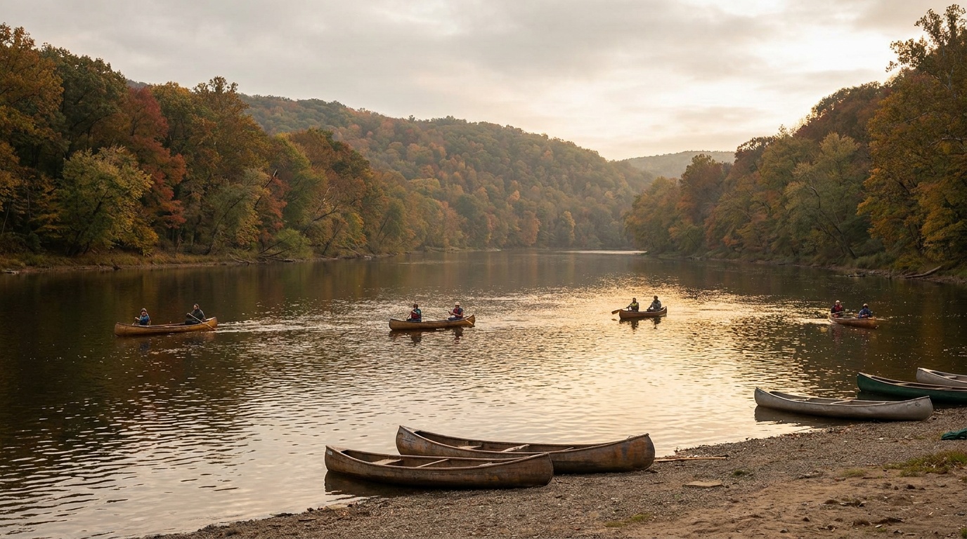
Middle Delaware River campsites

Details
Booking
Reserve by zone on Recreation.gov; season opens in mid-spring.
Season
Open roughly mid-April through fall.
Sites
More than 60 primitive canoe-access sites along the river, reserved by zone.
The signature overnight, built for canoe and kayak float trips rather than car camping.

Nearby private campgrounds

Details
Booking
Book directly with each campground.
Season
Mostly seasonal.
Sites
Developed private campgrounds and liveries near the river for car campers.
Use these when you want a drive-in base and a paddling shuttle rather than primitive river sites.

Getting there and practical info

The Delaware Water Gap with the river cutting between Mount Tammany and Mount Minsi

Plan the handoff from arrival to shuttle.

Parking, pedestrian entrances, and shuttle timing decide how calmly the first morning starts.

Getting there

Get to Delaware Water Gap National Recreation Area, then remove the first-morning friction.

Nearest airport
Lehigh Valley International (ABE), about 45 minutes from the Water Gap
Access rhythm
Car required
Region
Pennsylvania
  1. Arrival note

    The recreation area straddles the Delaware River for about 40 miles along the Pennsylvania and New Jersey border, easiest to reach off Interstate 80 at the water gap itself, about 90 minutes from New York City and Philadelphia.

  2. Car strategy

    A car is essential to move between the Pennsylvania waterfalls, the New Jersey trailheads, and the river launches, since the park is long and linear with access points on both banks.

Pair this with lodging: sleep where the park transfer is simple, especially if your route needs an early start.

LocationPennsylvania

Frequently asked questions

Is there an entrance fee at Delaware Water Gap National Recreation Area?

There is no general per-vehicle entrance fee. New amenity fees of $5 to $25 apply at certain beaches, boat launches, and picnic areas during the peak season from roughly Memorial Day through Labor Day.

How do you camp along the Delaware River?

The signature camping is primitive river sites reached by canoe or kayak, reserved by zone through Recreation.gov. River campsites open in mid-spring, and the system is built for multi-day float trips rather than drive-up camping.

How hard is the Mount Tammany hike?

It is the hardest hike in the park: a steep climb of about 1,200 feet over roughly 3.5 miles on loose rock, with a spectacular cliff-top view of the water gap. Wear real footwear and carry water.

Which waterfalls are easiest to reach?

Dingmans Falls and Raymondskill Falls on the Pennsylvania side are reached by short walks and boardwalks, making them the easiest big payoffs in the park.

Keep planning