Hole-in-the-Wall Campground
Details- Season
- Year-round
- Sites
- Developed first-come tent and RV sites with water, tables, fire rings, and pit toilets.
- The main developed base, near the dramatic Hole-in-the-Wall rings trail.
National Park Service · California
A 1.6 million acre desert wilderness between Los Angeles and Las Vegas, with singing sand dunes, a Joshua tree forest, lava cinder cones, and free dispersed camping.
Field briefing
Mojave National Preserve changes fast with season and elevation.
Before you go
There is almost no water, fuel, or cell signal across 1.6 million acres, so you carry in everything, especially water, and tell someone your plan. The headline hike is the Kelso Dunes, a field of singing sand that can hum and boom as you climb it. Camping is famously flexible: two developed campgrounds plus legal free dispersed camping at established roadside sites, including spots near the Kelso Dunes trailhead. Time a visit for October through April; summer heat at the low elevations is severe.
The landmarks worth the trip. Tap any photo to enlarge.
Weather, crowds, and what the season changes about the trip.
Warm, often windy days with possible wildflower and Joshua tree bloom before summer heat.
Pack Wind shell, sun protection, and all your own water; there is almost none out here.
100F
Very hot at lower elevations, often over 100F, with cooler air only on the high mesas.
Pack Heat planning, abundant water, and high-elevation routes instead of the dunes at midday.
Cooling, clear, and calm, with excellent hiking and some of the darkest night skies anywhere.
Pack Layers for cold nights, a full water supply, and a headlamp for the stars.
Cool to cold, with chilly nights, occasional snow on the high ground, and crisp clear days.
Pack Warm layers, a real sleeping setup for cold dispersed nights, and full water.
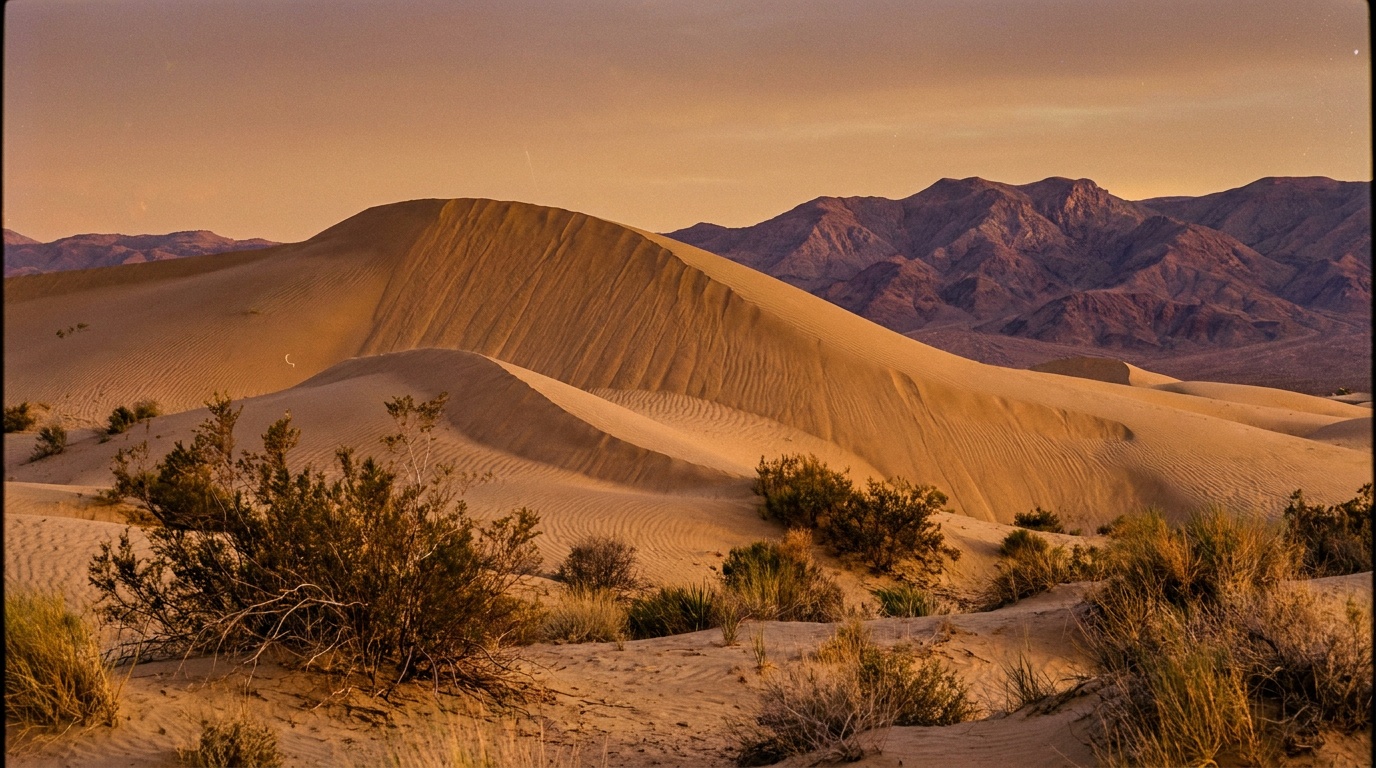
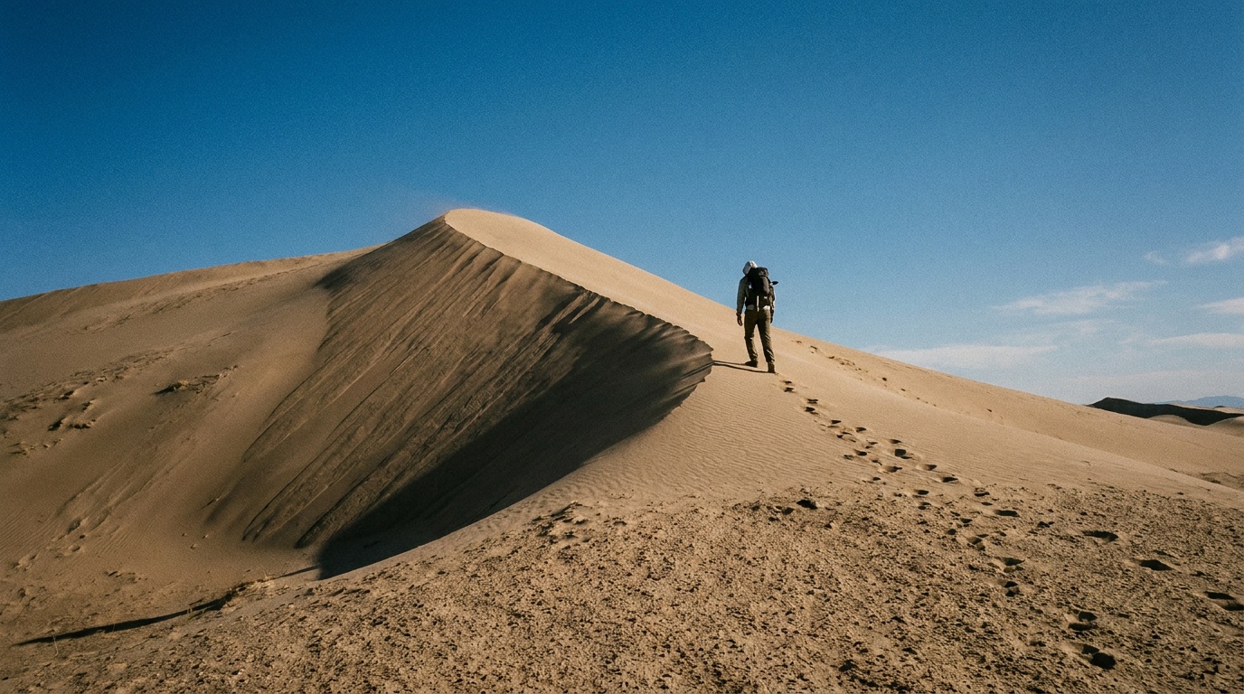
Kelso Dunes
A 650-foot field of singing sand that can boom and rumble as it slides underfoot. The preserve's signature hike.
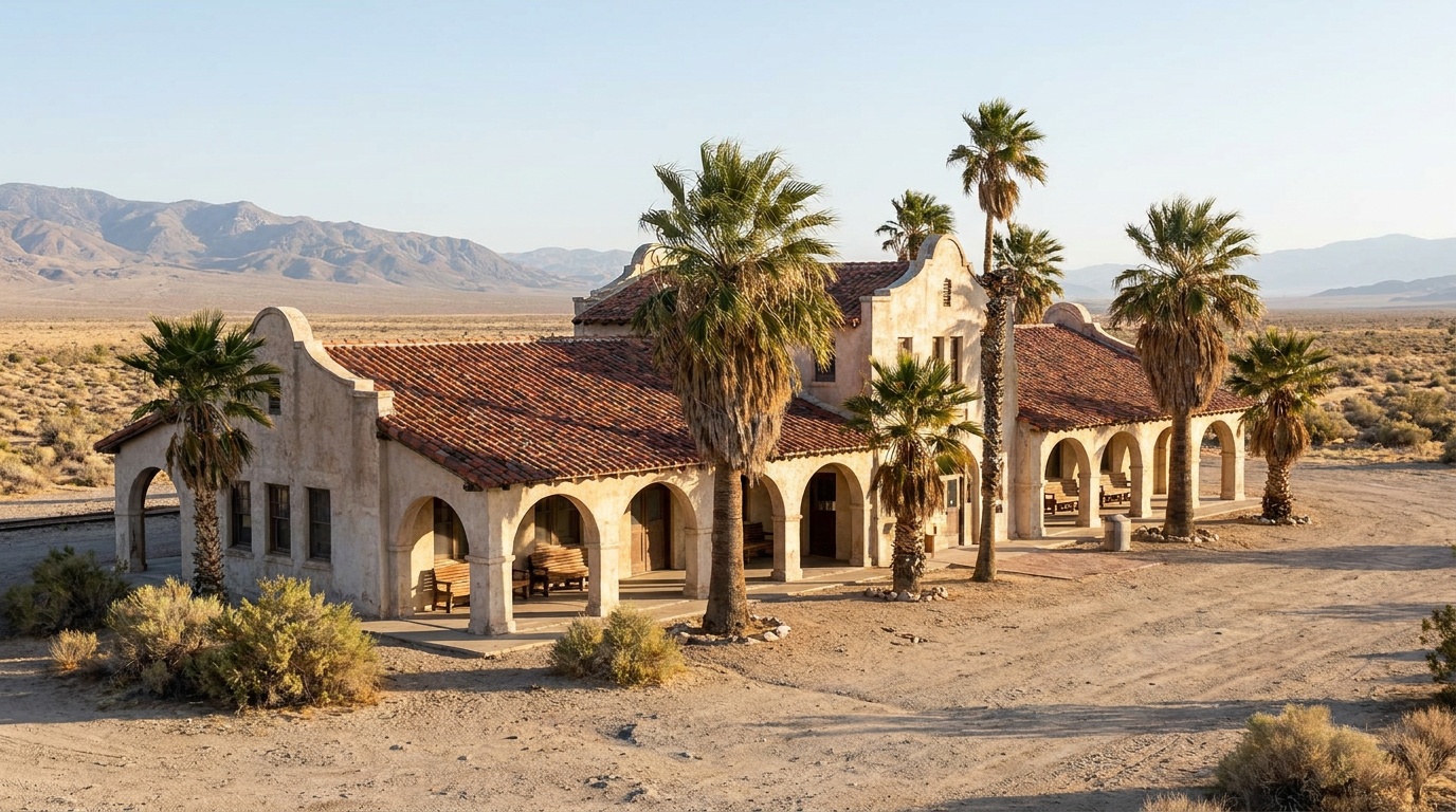
Kelso Depot Visitor Center
A restored 1920s Spanish-revival rail depot at the heart of the preserve, the main orientation point and a striking photo stop.
Teutonia Peak and the Cima Dome Joshua tree forest
A climb through one of the densest Joshua tree forests on earth to a granite summit with wide desert views.
Move exposed miles to the morning and keep water, shade, and storm checks ahead of the wish list. For one day in Mojave National Preserve, make Kelso Dunes the non-negotiable, add Kelso Depot Visitor Center only if the first stop runs clean, and keep Teutonia Peak and the Cima Dome Joshua tree forest as the flexible finish.
Turn Mojave's conditions into water, pack, and sleep-system decisions.
Build around conditions
Let season, elevation, and weather set the plan.
Plan your trip
4 quick tools, already seeded for Mojave National Preserve. Tune the numbers around temperature swings, footing, layers, and how much margin the route needs.
Start with the gear decisions this park changes: footing, weather, camping, and water.
Kit Authority
Mojave National Preserve packing list
0 of 24 packed. Check items as you pack, then take this list to the store, trailhead, or campsite.
Pack planning
Use this as a constraint check while you are still shaping the trip. The active checklist becomes useful once your route, dates, and sleep plan are set.
Checklist mode
24 items, grouped for the trip you are actually taking.
The buying guides that match what Mojave asks of your kit, with our current top picks across budget and use case.
Inside the preserve, the choices are Hole-in-the-Wall and Mid Hills, two developed first-come campgrounds, plus free dispersed camping at established roadside pullouts used traditionally for that purpose. There is no lodging in the preserve. For a roof, the gateway towns are Baker and Barstow to the west and Primm or Las Vegas to the east, all an hour or more from the interior. Most people who want the real experience camp.
Camping reservations
Mojave is one of the easiest NPS units to camp in spontaneously: Hole-in-the-Wall and Mid Hills are first-come developed campgrounds, and free dispersed camping is allowed at established roadside sites, including pullouts near the Kelso Dunes trailhead. The catch is total self-sufficiency, since there is almost no water or fuel anywhere in the preserve.
Reviewed June 11, 2026
Booking window
Developed campgrounds are first-come, first-served. Dispersed camping needs no reservation but must use already-established roadside sites.
Where to book or verify
NPS page covering both developed campgrounds and the rules for free dispersed camping.
The official rules for where free dispersed camping is allowed across the preserve.
Check for federal campground, backcountry, tour, and permit inventory tied to this park.
Campgrounds to know
Plan the last mile as carefully as the destination.
Airports, roads, entrances, and local movement belong in the same plan.
Getting there
Arrival note
Mojave National Preserve sits between Interstate 15 to the north and Interstate 40 to the south, roughly halfway between Los Angeles and Las Vegas.
Car strategy
Kelbaker Road and Cima Road drop south from I-15, and Essex Road and Black Canyon Road climb from I-40, all converging on Kelso Depot in the middle.
Car strategy
Distances are large and services nearly nonexistent, so fuel up in Baker, Barstow, or Primm and carry far more water than you think you need.
Pair this with lodging: the simplest base is the one that removes a real morning problem, not just the one nearest the map pin.
No. Mojave has no entrance fee. You only pay if you stay at a developed campground, which is about $12 per night; dispersed camping is free.
Yes. Free dispersed camping is allowed at sites that have traditionally been used for it, including roadside pullouts near the Kelso Dunes trailhead. Use established spots only, do not create new ones, and pack out everything. There are also two developed campgrounds for a modest fee.
A 650-foot field of fine sand that can sing, a low boom or rumble produced as the dry sand slides during an avalanche underfoot. The hike to the high crest is about 3 miles round trip and is the preserve's signature outing.
Yes, all of it. The preserve is 1.6 million acres with almost no water, fuel, or cell signal. Carry far more water than you expect to use, fuel up before you enter, and tell someone your route.